Water Resources
PROFILE OF THE DEPARTMENT/ORGANIZATION
Introduction:
Vision
Optimal sustainable protection of the state of Assam against flood and river bank erosion including providing relief to the drainage congested areas of the state.
Mission
- To develop policies, programmes and practices, formulation and execution of schemes/projects which would enable optimum management of floods and control the river bank erosion including providing optimum relief to the drainage congested areas of the state with active involvement of all stakeholders for reducing the damages due to flood to minimum level.
- To put into place systems and practices, which would result in sustainable increase in flood and erosion protected areas of the state for all round development.
- To actively engage with the neighbouring countries and states for evaluation and execution of effective measures for flood management in the state.
- To disseminate information, skills and knowledge, which would help in capacity building and mass awareness.
Objectives
- To control river bank erosion
- To prevent flood inundation
- Drainage development
- Land reclamation and river channelization
- Collection of hydro-meteorological data
DIFFERENT WINGS OF THE ORGANIZATION IN THE KAMRUP DISTRICT
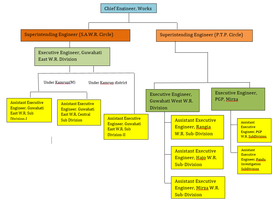
The flood and erosion management including all other related activities of the Water Resources Department in the Kamrup District is managed by the following three divisions headed by the Executive Engineer.
- Guwahati West Water Resources Division
- Guwahati East Water Resources Division
- Palasbari Gumi Water Resources Division
Guwahati West W.R. Division
The jurisdiction of Guwahati West Water Resources Division in the Kamrup District consists of three Sub-Divisions each headed by the respective Assistant Executive Engineer. The Sub Divisions namely are Rangia, Mirza and Hajo. Rangia Sub-Division has its jurisdiction over Rangia and Kamalpur constituency while Mirza Sub-Division looks after Boko and Chaygaon constituencies. As for Hajo Sub-Division, it has its jurisdiction over the Hajo constituency. These Sub-Divisons with juridictions and the major rivers under them as shown in the table below:
| SUB DIVISION | NAME OF RIVER | CONSTITUENCIES OF JURISDICTION |
|---|---|---|
|
Mirza W.R. Sub-Division |
Brahmaputra, Kulsi, Jaljali, Singra |
Chaygaon, Boko |
|
Hajo W.R. Sub-Division |
Brahmaputra ,Puthimari, Hajosuti, Bhoiratoljan |
Hajo |
|
Rangia W.R. Sub-Division |
Puthimari, Borolia, Noona |
Kamalpur, Rangia |
Contact us:
- Office Address: O/o the Executive Engineer, Guwahati West W.R. Division, Bharalumukh, Ghy-09
- Name, Designation & Official Contact No. of Head: Sri Pranab Borah, Executive Engineer, Ph No. 9954502522
- Official email id: guwest.wrd@gmail.com
RIVER SYSTEM UNDER GUWAHATI WEST W.R DIVISION
- Brahmaputra: The river Brahmaputra is a classic example of a braided river with multiple channels as well as lateral sand bars called chars formed due to excessive sediment load. The great earthquake of 1950 is considered as a major cause of unstable character of the river. It is the largest river in the state of Assam having its source in the Mansarovar Lake in Tibet. Flowing through Tibet, where it is known as Yarlung Tsangpo, it slowly bends and enters into Arunachal Pradesh where they call it Siang/Dihang river. The Dihang, winding out of the mountains, turns towards the southeast and descends into a low-lying basin as it enters northeastern Assam state. Just west of the town of Sadiya, the river again turns to the southwest and is joined by two mountain streams, the Lohit, and the Dibang. Below that confluence, about 1,450 km (900 mi) from the Bay of Bengal, the river becomes known conventionally as the Brahmaputra ("Son of Brahma"). In Assam, the river is mighty, even in the dry season, and during the rains, its banks are more than 8 km (5.0 mi) apart. As the river follows its braided 700 km (430 mi) course through the valley, it receives several rapidly flowing Himalayan streams, including the Subansiri, Kameng, Bhareli, Dhansiri, Manas, Champamati, Saralbhanga, and Sankosh Rivers. The main tributaries from the hills and from the plateau to the south are the Burhi Dihing, the Disang, the Dikhu, and the Kopili. Considering the confines of the Kamrup Rural District and the jurisdiction of Guwahati West W.R. Division, the river Brahmaputra and the effects it has on the general public is under the jurisdiction of Mirza W.R. Sub-Division and Hajo W.R. Sub-Division. Hajo W.R. Sub-Division looks after the portion starting from Shrihati near Sualkuchi town to near about the point where the Puthimari river falls and joins into Brahmaputra covering a length of about 15.00 Km along the right bank of the Brahmaputra. As for Mirza Sub-Division, it has a total lookout length of 21.38 Km along the left bank of this gigantic river system.
- Puthimari: The river Puthimari is a tributary of the mighty Brahmaputra has its source in the hills of Bhutan and flows through an alluvial plains region of the state of Assam and confluences with the mighty Brahmaputra near seven km D/S of Hajo town after traversing a length of 150 Km. The catchment area of river Puthimari is around 1774 Sq. Km which falls in both India and Bhutan. The Indian catchment falls entirely in the state of Assam and mostly covered with crop growing field and homestead land. The river has an acute meandering nature in its journey through the alluvial plains and has a series of very sharp curves with reversed flow to the original channel which makes the entire river system unique having a very wider. The river Puthimari is very flashy having heavy silt loaded discharge during monsoon period.
- Bhoiratolajan: The river Bhoiratolajan initially was a narrow channel which was fed up by excess water of river Baralia. During the year 1985-86 a major part of Barkhetri LAC was inundated due to heavy flood by river Baralia and Pagladia and created havoc to the inhabitants. The Baralia river originates from Bhasbari near Nagrijuli tea Estate. A small river namely Balti also joins this river near Kuchibari. Another sub-tributary Noona having sufficient water potential during monsoon also joins the Baralia few Km U/S of the mouth of Bhairatolajan near Chmukha Bazar from where the behavior of the river becomes turbulent. To overcome this problem in Barkhtri LAC (particularly in Barbhag areas) the existing narrow channel “Bhoiratolajan” was re-graded and re-sectioned in the year 1984-85. After this the water flow becomes straight towards this channel. Before this the Baralia river had its outfall at river Pagladia by taking a sharp meandering to Bhoiratolajan after passing 5.50 Km downwards.The excess water of Baralia river passes through the Bhoiratolajan canal and falls in the Puthimari river downstream. During this operation both bank inundation of Bhoiratolajan have been protected by construction of embankment of 3.50 km in both bank. At present maximum discharge of Baralia river (almost 95%) flows through this Bhoiratolajan river and water current erodes the bank in its meandering zone.
- Hajosuti: The river Hajo Suti originates from Hatiputa Bill and Lowtoli area of Kamrup district of Assam & flowing through Sessamukh ,Goraghat, Mowamari, Tokradia and Khetrihardia village and falls at river Brahmaputra near village Ganghilitary. The river has sharp bend everywhere . The river bed gradient assums 1:3000(In plain reaches). The river flows in a meandering nature and it starts eroding its bank at one place or the other, particularly on its concave bends.
- Singra: The river Singra originates from the foothills of Meghalaya joins river Gijang and follows a meandering path with its outfall at Jaljali. The river is flushy in nature with steep gradient. Due to flashy in nature, the river flows with tremendous velocity causing severe migration along its course where it directly hit the bank. One such a location is Hahim Bazar area where the river has already migrated a major portion of this remote market area.
- Kulshi/Jaljali: The river Kulshi originates from the foothills of Meghalaya and joins with the other tributaries and flow through thickly populated area of Chaygaon and Boko LAC. The river is flashy in nature. During heavy rainfall at the catchment area in monsoon the flash flood occurs at river Kulshi resulting high velocity of flow due to which always active migration occurs on both banks. During the flood of 2018& 2019, the village road on L/B of the river Kulshi was badly damaged at Chaygaon town area and near D/S of Singkhat R.C.C. bridge ( Cremation ground). Ultimately, as the heavy shower occurred in the months of June and July of 2020 at the upper catchment area of Kulshi at Meghalaya and flowing with high velocity resulting severe damage of the village road at that said areas inundating several localities which is one and only the communication path of the whole people of that entire areas .The river Kulshi originating from Meghalaya Hill Ranges in Meghalaya and passes through the plain land of Assam bifurcates into two small branches at Bherveri which crosses NH-37 at Kukurmara and Chhaygaon and joins again at SapartariParghat near Gumi . Again from Gumi to Chamaria, there are some other tributaries joining the Kulsi, namely, Kharkhari, Boko. The river in this portion is known as “Kharkhari”and thereafter from Chamaria to Nagarbera the river is known as Jaljali. At the downstream of Chamaria the river Singra joins the river Jaljali. The river Jaljali is meandering in nature and causing migration at various locations along its length up to its outfall at Nagarbera. It has been causing migration for the last few years at several locations
- Baralia: The river originates from Bher Veri Bhumukh near Nagarjuli Tea Estate. A part of the escape discharge of river Barnadi (Puthimari) also feeds the river throughout the year. The river flows to the west of river Puthimari and almost parallel to it up to R.G Railway Line and finally falls at river Pagladia near Dusutimukh. The river runs through the Sub-Divisional head quarter town of rangia of Kamrup District. It is highly flashy and meandering in nature. Due to its meandering nature, deposition of heavy silt at the concave bends on either sides and at the bed of the river and banks inside the embankment system is increasing day by day. Thus, the water carrying capacity of the river is also decreasing which makes this a critical river for the Division.
- Noona: The river Noona is a sub-tributary of the river Brahmaputra having its source in the Bhutan foot hills and flows through a length of approximately 58 Km through alluvial plain region of Assam and ultimately outfalls at Baralia river near Chowmukhaghat. The catchment area of this river falls both in India and Bhutan. The Indian catchment falls entirely in Assam which is mostly covered with crop growing fields and homestead land. The basin is located in between 26°10’ to 26°48’ and Longitude 91°18’ to 92°45’. The nature of the river Noona is flashy having a heavily silt loaded discharge during monsoon period. Due to heavy silt deposition and meandering nature , the river changes its course frequently.
JURISDICTION MAP OF SUB–DIVISIONS UNDER GUWAHATI WEST
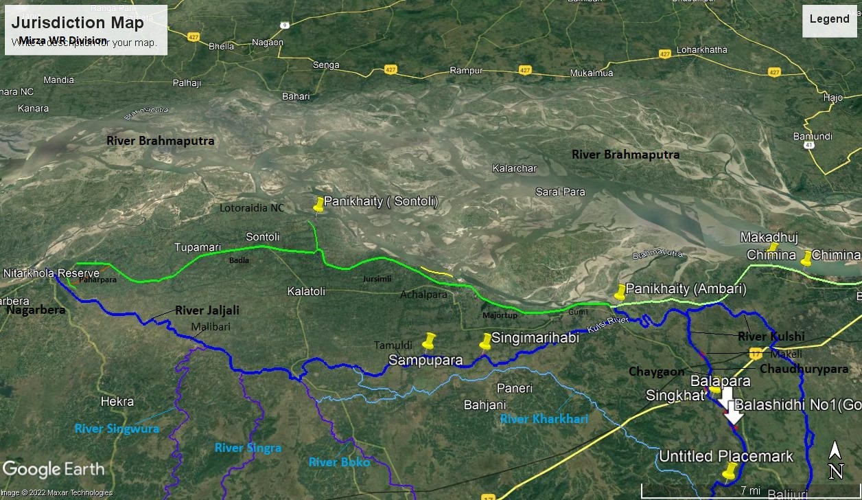
Jurisdiction map of Mirja W.R. Sub-Division
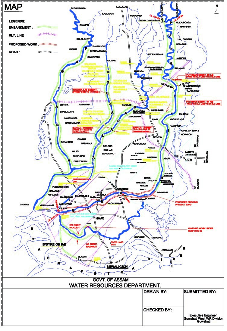
Jurisdiction map of Hajo & Rangia W.R. Sub-Division
EMBANKMENTS UNDER GUWAHATI WEST:
| SUB DIVISION | NAME OF RIVER | NAME OF EMBANKMENT | LENGTH OF EMBANKMENT |
|---|---|---|---|
|
Mirja |
Brahmaputra |
Gumi-Nagarbera on L/B |
38.70 km
|
|
Brahmaputra |
Sontoli Ring Bund |
2.20 km
|
|
|
Jaljali |
Jaljali Guide Bund |
5.00 km
|
|
|
Kulsi |
Alegzari Embankment R/B |
3.10 km
|
|
|
Singra |
Singra Dyke |
0.625 km
|
|
|
Hajo |
Brahmaputra |
Hatimura-Adabari R/B |
6.80 km
|
|
Puthimari |
Both Bank Embankment |
31.00 km
|
|
|
Hajo-Suti |
Both Bank Embankment |
10.20 km
|
|
|
Bhoiratolajan |
Both Bank Embankment |
7.00 km
|
|
|
Rangia |
Puthimari |
Both Bank Embankment |
63.00 km
|
|
Baralia |
Both Bank Embankment |
27.00 km
|
|
|
Noona |
Left Bank Embankment |
17.00 km
|
FLOOD FORECASTING
Flood Forecasting in the Kamrup District during Monsoon season is managed through various rain gauge stations and Water Level Gauge stations located at different locations given below.
Water Level Gauge Station
| River | Station | H.F.L. in m | H.F.L. Date | D.L. in m |
|---|---|---|---|---|
|
Brahmaputra |
Dibrugarh |
106.48 |
03.09.1998 |
105.70 |
|
|
D.C. Court, Guwahati |
51.37 |
28.08.1988 |
49.68 |
|
|
Alikash |
46.08 |
17.08.1988 |
44.20 |
|
|
Siliguri |
49.22 |
28.08.1988 |
47.30 |
|
Puthimari |
N.H. Road Crossing |
54.96 |
20.06.1993 |
51.81 |
|
|
N.H. P.W.D. Bridge at Baruahbari |
49.40 |
20.08.1988 |
48.20 |
|
Baralia |
N.H. Crossing |
53.33 |
|
51.98 |
|
Noona |
N.H. Bridge Crossing |
52.00 |
|
52.00 |
Rain Gauge Station
There are three rain gauge stations under the three Sub-Divisions of Guwahati West W.R. Division. The rain gauge station under Hajo W.R. Sub-Division and Rangia W.R. Sub-Division are present in the office campus itself. The rain gauge station under Mirza W.R. Sub-Division is present at Alikash.
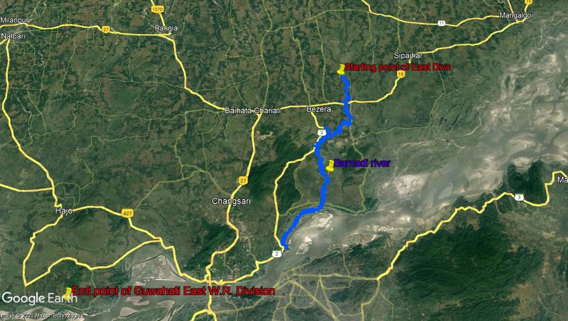
Guwahati East Water Resource Division: